This article's factual accuracy may be compromised due to out-of-date information. The reason given is: Since the 2017 administrative reform, the parish also contains the town of Jõgeva, as well as the territory of two former adjacent parishes. The map shows the present situation. (July 2020) |
Jõgeva Parish (Estonian: Jõgeva vald) is a rural municipality of Estonia, in Jõgeva County.[1] It has a population of 12,413 (2024) and an area of 458 km2 (177 mi2).
Jõgeva Parish
Jõgeva vald | |
|---|---|
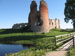
 Ruins of Laiuse Castle | |
 Jõgeva Parish within Jõgeva County. | |
| Country | Estonia |
| County | Jõgeva County |
| Administrative centre | Jõgeva |
| Government | |
| • Parish Elder | Taavi Aas |
| Area | |
• Total | 458 km2 (177 sq mi) |
| Population (2018) | |
• Total | 13,513 |
| • Density | 30/km2 (76/sq mi) |
| ISO 3166 code | EE-247 |
| Website | www |
Populated places
edit- Towns
Jõgeva (administrative center)
- Small boroughs
Kuremaa - Laiuse - Palamuse - Sadala - Siimusti - Torma
- Villages
Alavere - Änkküla - Eerikvere - Ehavere - Ellakvere - Endla - Härjanurme - Imukvere - Iravere - Järvepera - Jõune - Kaarepere - Kaave - Kaera - Kaiavere - Kantküla - Kärde - Kassinurme - Kassivere - Kaude - Kivijärve - Kivimäe - Kodismaa - Koimula - Kõnnu - Kõola - Kudina - Kurista - Laiusevälja - Leedi - Lemuvere - Liikatku - Liivoja - Lilastvere - Lõpe - Luua - Mooritsa - Mullavere - Mõisamaa - Nava - Näduvere - Ookatku - Oti - Õuna - Paduvere - Painküla - Pakaste - Palupere - Patjala - Pedja - Pikkjärve - Pööra - Praaklima - Rääbise - Raadivere - Raaduvere - Rahivere - Rassiku - Reastvere - Rohe - Ronivere - Saduküla - Sätsuvere - Selli - Soomevere - Sudiste - Süvalepa - Tealama - Tähkvere - Teilma - Tõikvere - Tooma - Toovere - Tuimõisa - Vägeva - Vaiatu - Vaidavere - Vaimastvere - Väljaotsa - Vana-Jõgeva - Vanamõisa - Vanavälja - Varbevere - Vilina - Viruvere - Visusti - Võduvere - Võidivere - Võikvere
Religion
edit- Unaffiliated 84 (83.2%)
- Lutheran 9.2 (9.11%)
- Orthodox & Old Believers 3 (2.97%)
- Others Christians 1.3 (1.29%)
- Others Religions 3.5 (3.47%)
- 0 (0.00%)
See also
editReferences
edit- ^ "X-GIS(3) Portal". xgis.maaamet.ee. Retrieved 31 January 2022.
External links
edit58°48′47″N 26°17′31″E / 58.813°N 26.292°E

